
Using Location-Based Safety Alerts to Protect Employees Anywhere
Your team’s distributed locations greatly expand safety variables and threats. Any measures that effectively increase your people’s safety and security will hinge on solid communication.
When communicating with your employees during a crisis, you need all the tools necessary to ensure quick, accurate, and easy transmission of alerts. One of the most powerful tools available is a modern mass communication system with location-based safety alerts, which include GPS tracking, map views, and geofencing.
Some organizations rely on location information in their day-to-day operations. For example, the International Justice Mission is an NGO that aims to protect people in developing regions from human trafficking, slavery, and other such crimes that impoverished people face. The organization’s employees often work in areas that are dangerous or unstable. To ask them to do so without support would be irresponsible, not to mention ineffective. International Justice Mission uses AlertMedia to communicate with those workers and monitor their location and any threats that might affect them. Without location data, it would be impossible for them to confidently see who is impacted by any number of emergencies and to ensure their people’s safety and well-being.
Current location is a primary factor in determining who is at risk in an emergency, so being able to receive and send that information is critical in a wide variety of events. If preparedness is your goal, (and it should be) then you need to have this capability.
What Are Location-Based Alerts?
Location-based alerts are notifications that leverage location intelligence to determine their audience. If you receive a hurricane evacuation order because you’re in a city impacted by that storm, that’s a location-based alert.
Mobile phone apps can determine a person’s location using services like GPS and cellular signal technology. For example, popular map apps employ these services to show you where you are and where you’re going for navigational purposes. There are also standalone GPS sensors you can buy and attach to objects for easy tracking—no smartphone required. Of course, you can also determine location with more low-tech methods, such as a simple list of employee addresses. But a static list will not suffice for traveling employees and nomadic remote employees, who also fall under your duty of care.
When you use different types of location data, it’s possible to target your alerts to a much more specific and relevant audience. Modern emergency notification systems should be able to pull off all of these sophisticated techniques to help you keep your people safe and secure.
Why use location-based safety alerts in emergency situations
Many emergencies your business might face won’t threaten your entire company. For example, say one of your satellite offices experiences a power outage. Your emergency response plan might indicate that all employees stationed at the affected office should work remotely for the day. If you took a location-blind approach to communicating these instructions, you might inadvertently send a message to the wrong office or people.. By using location-based alerts, you can carefully target your audience based on geographic location, avoid excess panic and worry, and maintain continuity of operations to the greatest extent possible.
And you can forget about manually contacting individual workers. Not only is that method prone to errors, it’s going to take many, many times longer than a modern software-based system would. This makes options like the outdated phone tree a very bad idea in this day and age.
Using maps in an emergency
Perhaps the most obvious way to gather location data is through a map view. Maps are incredibly powerful because they can show you at-a-glance where problems are as well as the people and places they might impact. In the heat of the moment, you might have trouble remembering which office is where, and keeping track of your employees’ locations in your head is impossible. But with a map, you can access all this information instantly.
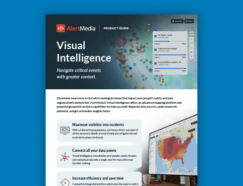
Maps allow you to distribute alerts with surgical precision. Some emergencies, such as wildfires, affect locations unpredictably. Fires can meet barriers like roads or bodies of water and stop in their tracks. So one employee might live less than a mile from another, but the impacts they see could be very different. It’s important to be able to match that unpredictability with accuracy. Using a map that synchronizes emergency information and employee locations allows you to see who’s in danger without wasting time, so you can prioritize safety actions. AlertMedia’s next-generation mapping and geospatial analysis suite, Visual Intelligence, provides a dynamic view of the context around critical events.
On an episode of The Employee Safety Podcast, Erica Reed, Business Resiliency Analyst at Macy’s, explains how location data allows them to visualize the location, size, direction, and impact of wildfires in the vicinities of their stores, as well as the homes of employees. When combined with AlertMedia’s mass notification abilities, Macy’s safety leaders are empowered to help their people avoid danger and get to safety. Reed says this allows their emergency management team to “stay as far ahead of these incidents as we possibly can and take as proactive of an approach as possible.”
Finally, maps are perfectly suited to include data on large events, such as weather and natural disasters. We already use maps to display how storms and other dangerous weather patterns move. Layering that on top of your existing location data can be extremely valuable. With this synergy, you can easily determine who is at risk of encountering bad weather and send location-based safety alerts accordingly. When researching which emergency alert system is right for you, be sure to look for products that include these essential map features.
Safeguard Your Business Travelers and Remote Workers With Location Data
Office work environments have evolved rapidly since the start of the COVID-19 pandemic to the point where 25% of all professional jobs in North America are based remotely, a trend that is expected to continue into 2023. Simultaneously, business travel has rebounded from its steep drop in 2020. All of this leads to a changed working landscape and a particular problem for safety leaders: A growing portion of your people won’t work in the primary office or workplace but instead might log in from anywhere in the world at any time, and you still have to keep them safe.
This can quickly become overwhelming. Suppose you’re responsible only for monitoring the area of your home office for potential danger to your workers and operations. In that case, the scope of your responsibility is limited, unchanging, and familiar. But if you add remote or traveling employees to the mix, the physical areas that are your purview will quickly balloon to an unmanageable size. That’s why automating the brunt of this work with location data is necessary to keep up with changes in real time.
Employee Data to Consider
Physical location
The most basic location information might already be in your HCM system. Most modern emergency communication systems allow you to import employee location data, such as their home address, office location, and phone number or other contact information. This level of awareness allows you to make educated guesses about where your employees are and what notifications may or may not be relevant to them. Keep in mind that this information is static and will not change unless you update it in your system of record.
RFID check-in
One of the most popular security tools in offices around the world today is the RFID-enabled ID card. You’ve probably come across these before: credit card-sized plastic rectangles that employees can use to unlock doors electronically, clock into work, or access business systems. By integrating your RFID system with your ENS, you can get real-time updates on employee location and know when your people enter or leave a location. Your emergency communication system should be able to send location-based safety alerts using this RFID check-in data.
Travel schedules
Any worthwhile emergency communication system should be able to protect your employees while at their desks as well as when they’re traveling for work. One way to easily import travel data is by integrating your employee notification system with your business’s Corporate Travel Management system, which will automatically update your traveling employees’ locations. You can rest assured that you’ll be able to send accurate, relevant alerts to your workforce regardless of location.
Mobile app / GPS services
These days, about 81% of Americans use some kind of smartphone. These mobile devices are equipped with GPS modules that can transmit geographic coordinates in real time. This is enhanced by the fact that most people carry their cell phones with them at all times, increasing accuracy. With your emergency notification app, you can tap into this wealth of GPS information to automatically track where your employees are.
Luckily, if any of your employees are not comfortable with that, they should be able to opt out of GPS tracking, ensuring that everyone is comfortable with how their data is handled. But be sure to remind doubtful employees that their location will be used only to keep them aware of imminent threats. It is there to keep them safe, not surveil them for other reasons.
GPS data is the most reliable source for location-based alerts. While the other sources of location data are good approximations, they are all, to some extent, ways of checking where someone is “supposed” to be. GPS data, by contrast, checks the person’s real-time location—whether they are “supposed” to be there or not. For this reason, you should rely on GPS data whenever possible.
Geofencing
Having access to location data is only half the battle, though. You also need a way to send alerts based on that location data. The best way to accomplish this is through geofencing. With geofencing, you can quickly and intuitively choose your notification’s audience with a click and a drag.
Geofencing allows you to draw a “fence” around a particular area of the map. The system then automatically includes everyone in that area in the audience. This can be incredibly useful when you have to immediately send out a notification to those affected by, say, a flash flood. You may not have time to think about which of your groups or locations you should include in your notification. But if you’re using a robust employee notification system with geo-targeting, on just one screen, you can quickly draw a circle on the map around the affected area, including everyone you need to and excluding everyone you don’t.
Intelligent location-based alerts
To this point, we have assumed that there is some specific reason that you know you need to send an alert. This might sound obvious, but realistically this often won’t be the case—or at least not quickly.
Consider the tragic case of an active shooter event. As soon as a gunman opens fire, lives are at risk. In a situation like this, you need—immediately—to communicate with any employees in that area, telling them to take cover inside and avoid the festival area.
If you happened to be watching the news late that evening, you could do just what we have described in this article. You could open up your emergency communication system, draw a geofencing circle around a city or neighborhood, and send a location-based alert to everyone at risk.
But how likely is that? The fact is, it’s very unlikely that you would be able to monitor the news at all times. If you rely on your own ability to monitor threats manually, the alert wouldn’t go out until far too late.
Intelligent location-based alerts solve this problem. Threat monitoring systems, like AlertMedia’s, are constantly looking for threats worldwide. Whenever a threat emerges, the system immediately cross-references the location of the threat with the location of your people and assets. Then, the system automatically sends a threat warning—either to you or to your people directly. (You decide which threats merit a direct notification to your employees. For example, you can specify that the warning system should send an alert directly to end-users only for high-severity threats, like an active shooter.) And if you need hands-on expert support, our Analyst Access team is available anytime to help guide your team through crisis events.
This system of intelligent location-based alerts operates 24/7—even when you’re asleep. It combines the power of location data with the immediacy of top-of-the-line threat monitoring.
In Practice
Some people are skeptical of the benefits a robust, GPS-integrated emergency notification system can provide. Such was the case with Kawasaki, one of the largest producers of motor vehicles in the world—before they put their system to use during a California wildfire. Kawasaki called upon AlertMedia’s pioneering map and geofencing technology to keep its employees safe and informed during the Inyo County fires several years ago.
As Kawasaki knows, every second counts in the effort to protect your people. For that reason, location data is most effective when it’s automatic. Implement a modern threat monitoring system so you don’t have to try to keep track of worldwide threats manually. Contact us if you’re looking to learn more about AlertMedia’s capabilities for location-based alerts.