Not all maps are created equal. In this post, we’ll walk you through the three different types of travel safety maps—and when to use each one.
Emergency Management Feb 02, 2020
The Three Types of Travel Safety Map
Travel Risk Assessment Template
Evaluate travel threats for any location to help prioritize your efforts and create a safety plan tailored to each trip.

Everyone has heard the saying: “Seeing is believing.” Of course, there are some limits to that sentiment, but the basic idea is simple. It’s easier to wrap your head around something when you can view it with your own two eyes.
That is the key advantage of a travel safety map. Instead of just having someone tell you about the threats associated with different areas, you can see them for yourself. Although there are several different types of travel safety maps, they all share the same basic idea. Every travel safety map visually displays the risks associated with different areas.
But it is also important to understand the different types of travel safety maps. All travel safety maps fall into three basic categories:
- Static Travel Risk Map
- Official Travel Advisory Map
- Integrated Travel Safety Map
In this post, we will walk through the three different types of travel safety maps—and when to use each one.
Download Our Travel Risk Assessment Template
Evaluate travel threats for any location to help prioritize your efforts and create a safety plan tailored to each trip.
#1) Static Travel Risk Map
The first type of travel safety map is a static travel risk map. This is the most basic type of map, but it can still be useful for your organization if used correctly.
The reason it is called a “static” map is that it is updated very rarely—typically annually. A static travel risk map is not meant to capture any specific threats. Instead, it’s just supposed to give you a baseline understanding of how dangerous an area is on average.
One example of a static travel risk map is International SOS’s interactive map. It color-codes each country across three dimensions:
- Medical
- Security
- Road Safety
You can see, for example, the automobile accident mortality rate for each country, color-coded on the map. Venezuela has a mortality rate of over 25 deaths per 100,000 people. Canada, on the other hand, has under 10 deaths per 100,000 people.
The map is updated annually, like most static travel risk maps. This means that it gives your organization a helpful baseline understanding of the danger of traveling to each country. Based on this understanding, you may decide to put certain countries on your company’s “no travel” list. Or you may implement certain policies that will apply whenever your employees travel to specific countries. (For example, you may enact a requirement that business travelers always use trained drivers when on business in Venezuela.)
Disadvantages of a Static Travel Risk Map
But keep in mind the limitations of static travel risk maps. These maps do not contain information on any specific threats. If there is an act of terror in a certain country, that will never make it onto the map. Even specific ongoing threats will not show up on the map. For example, if there is a new disease outbreak in a country, that won’t show up on a static map either, but an ongoing pandemic like the one we’ve seen with COVID-19 will.
For specific threats, you will need to rely on the next two types of travel safety maps.
#2) Official Travel Advisory Map
The next type of map is an official travel advisory map. This type of map does display specific threat information, and it’s typically updated daily. These maps are usually generated by the country’s State Department—as a compilation of the country’s official travel advisories. In the United States, you can find the official travel advisory map here.
There are several advantages to using official travel advisory maps. First of all, unlike static travel risk maps, they do have up-to-date threat information. The US government issues travel advisories for a variety of types of threats—from terrorist activity to disease outbreaks like COVID-19 to civil unrest. You can also see information on where the US embassy is located in each country.
Disadvantages of a Travel Advisory Map
But there are also multiple disadvantages of advisory maps. First of all, officials only these maps daily. This means that they will include multi-day threats—like disease outbreaks or weeklong rioting. But they won’t include one-time, immediate threats—like active shooters, fires, bomb threats, or specific acts of terrorism. These threats last for a matter of hours, not days, so they typically don’t result in an official travel advisory, and thus, never show up on the map.
Another drawback of advisory maps is that they are not company-specific. It is up to you to filter through all of the advisories displayed and determine which ones are relevant to you. If your organization is small—or only has one or two business trips going on at a given time—this may be feasible.
But for most companies, it is simply not reasonable to expect to be able to look at a map and remember exactly where all your people are. Before major trips, you should check the official travel advisory map to see if there are any pertinent notices (and your employees should do the same).
But if you want to be able to identify relevant risks quickly, at scale, you will need to turn to the third type of travel safety map.
Streamline business traveler safety for a range of possible threats.
#3) Integrated Travel Safety Map
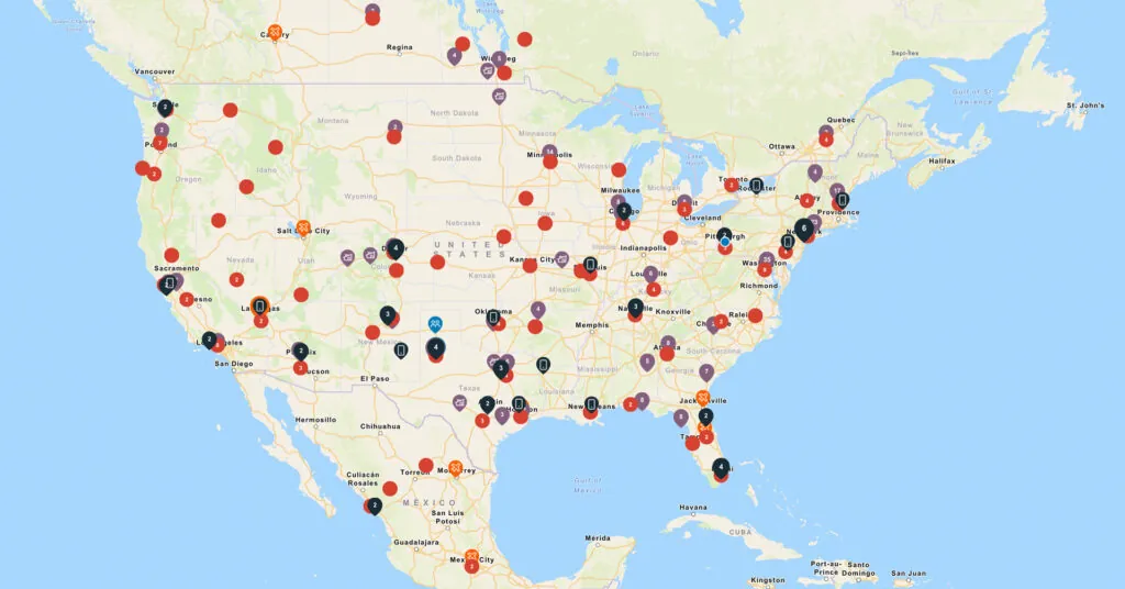
The final—and most robust—type of map is an integrated travel safety map. An integrated map is updated constantly, instead of yearly or daily. It includes granular threat data for specific threats—even short-term, hyperlocal ones. And most importantly, it integrates with your HR, travel management, and emergency communication systems.
An integrated travel safety map, like AlertMedia, works by cross-referencing worldwide threat data with the real-time locations of your people and assets. The system gathers its threat data from trusted sources and analysts around the world. It assigns a severity to each threat, as well as recommended action steps—and then populates those threats on the map. You can filter by threat type and threat severity.
Because it is integrated with your HR system, though, an integrated travel safety map is able to display your people and assets on the map as well. By using GPS data from your employees’ smartphones, you can send them location-based alerts based on their precise, real-time location. This makes it much easier to determine which threats are relevant to you. Instead of having to sift through threats worldwide, you can see where your people are and whether any of them are impacted by a current threat.
You can even have the system automatically notify you when a threat emerges. This means you don’t have to keep a tab open on your computer and check it constantly. As soon as one of your business travelers is at risk, you’ll know immediately.
Actionable Intelligence
An integrated travel safety map also makes threats actionable. Let’s say you get a notification that one of your business travelers is in a known epidemic hotspot. You immediately open up your integrated travel safety map and see that, sure enough, two of your business travelers are not far from the area. Since the map is integrated with your mass notification system, you can immediately draft a message to everyone in the radius of the threat—warning them to avoid unnecessary contact with others and to stay indoors. You don’t have to use another tool or type in names manually of who you need to communicate with.
The benefits of an integrated travel safety map are clear. If you are looking to implement a system that monitors for real-time threats and works with your existing solutions, it’s your only option.
Using the Right Map at the Right Time
Each type of travel safety map has its place in your travel risk management. The key is to know when to use each one—and when not to.
- If you are looking to develop a company “no travel list” or determine country-specific travel policies, use a static travel risk map.
- If you want to see US government guidance for ongoing threats in certain areas, look to an official travel advisory map.
- And if you want to implement a robust system that constantly monitors for threats, integrates with your existing solutions, and notifies you when your people are at risk—you need to implement an integrated travel safety map.
Download Our Travel Risk Assessment Template
Evaluate travel threats for any location to help prioritize your efforts and create a safety plan tailored to each trip.
AlertMedia, Risk Intelligence and Response
More Articles You May Be Interested In
-

 Emergency Management, Safety and SecurityWhat Is Narrative Intelligence—and Why Corporate Security Teams Are Paying Attention
 -
 Emergency ManagementAI Misinformation: A Business Guide to Spotting and Responding to AI-Generated False Content
 -
 Emergency ManagementWhat Is Geopolitical Risk? A Corporate Security Leader’s Guide